

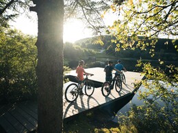
Liebenau route no. M5


Interactive elevation profile
Create PDF
Tour-Details
Path number: M5
Starting place: 4252 Liebenau
Destination: 4252 Liebenau
duration: 3h 9m
length: 39,2 km
Altitude difference (uphill): 860m
Lowest point: 829m
Highest point: 982m
difficulty: medium
condition: medium
panoramic view: Some Views
Paths covering:
Hiking trail
powered by TOURDATA
The mountain bike route is the connecting route to the mountain bike trail network of the Waldviertel. Coming from north of Karlstift, the route leads into the Liebenau municipality. Afterwards, you will continue on to the Tannenmoor/Rubenerteich (Rubenerteich moor pond) and then to the finishing point at the Moserwirt (Moserwirt Inn).
Continue to the Moserwirt (refreshment stop). The tour then takes you to Neustift and then makes a short detour into the Waldviertel. At the Neumühle mill, you cross the Großer Kamp and thus also the state border. After a stretch through the Taborwald forest, you head north and again into the Waldviertel. You then cycle southwards back to Liebenau.
Continue to the Moserwirt (refreshment stop). The tour then takes you to Neustift and then makes a short detour into the Waldviertel. At the Neumühle mill, you cross the Großer Kamp and thus also the state border. After a stretch through the Taborwald forest, you head north and again into the Waldviertel. You then cycle southwards back to Liebenau.
Starting point: Kamp source
- Suitable for groups
- Suitable for teenagers
- Suitable for single travelers
- Suitable for friends
- Suitable for couples
- Spring
- Summer
- Autumn
Please get in touch for more information.
4252 Liebenau
Phone +43 7956 7304
Fax machine +43 7956 7304 - 4
E-Mail office@muehlviertleralm.at
Web www.muehlviertleralm.at
Web www.tourdealm.at
http://www.muehlviertleralm.at
http://www.tourdealm.at
http://www.tourdealm.at
Interactive elevation profile
Create PDF
Tour-Details
Path number: M5
Starting place: 4252 Liebenau
Destination: 4252 Liebenau
duration: 3h 9m
length: 39,2 km
Altitude difference (uphill): 860m
Lowest point: 829m
Highest point: 982m
difficulty: medium
condition: medium
panoramic view: Some Views
Paths covering:
Hiking trail
powered by TOURDATA