

road "Radmoosstraße" in Gmunden


Interactive elevation profile
Create PDF
Tour-Details
Starting place: 4810 Gmunden
Destination: 4810 Gmunden
duration: 1h 51m
length: 5,2 km
Altitude difference (uphill): 346m
Altitude difference (downhill): 57m
Lowest point: 627m
Highest point: 935m
difficulty: easy
condition: easy
panoramic view: Great panorama
Paths covering:
Asphalt, Hiking trail
powered by TOURDATA
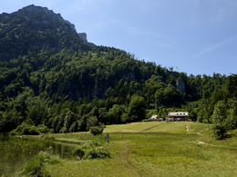
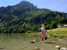
Starting point of this route is "Franzl im Holz" Laudachsee-Bezirksstraße-Buchberg-up to the forest near Hochgschirr-Radmoos
Than you can walk to the lake Laudachsee or to the mountain "Grünberg".
The mountainbike route goes till lake Laudachsee.
Than you can walk to the lake Laudachsee or to the mountain "Grünberg".
The mountainbike route goes till lake Laudachsee.
Starting point: Franzl im Holz
Destination: lake Laudachsee/Grünberg
")
")
karl_heinz_ruber (8) (© Foto: TVB Traunsee-Almtal/Karl-Heinz Ruber)")
Accessibility / arrival
from the highway:departure Regau-B 145 in the direction of Bad Ischl-through the center of Gmunden-across the bridge "Traunbrücke"-traffic circle first exit-in front of the Gasthof Engelhof turn right till Franzl im Holz
Most economical season
- Summer
Please get in touch for more information.
Toscanapark 1
4810 Gmunden
Phone +43 7612 74451
E-Mail info@traunsee-almtal.at
Web www.traunsee-almtal.at
http://www.traunsee-almtal.at
Interactive elevation profile
Create PDF
Tour-Details
Starting place: 4810 Gmunden
Destination: 4810 Gmunden
duration: 1h 51m
length: 5,2 km
Altitude difference (uphill): 346m
Altitude difference (downhill): 57m
Lowest point: 627m
Highest point: 935m
difficulty: easy
condition: easy
panoramic view: Great panorama
Paths covering:
Asphalt, Hiking trail
powered by TOURDATA