

Eisenau - Kreuzstein


Interactive elevation profile
Create PDF
Tour-Details
Starting place: 4866 Unterach am Attersee
Destination: 4866 Unterach am Attersee
duration: 3h 18m
length: 26,3 km
Altitude difference (uphill): 1.238m
Altitude difference (downhill): 1.240m
Lowest point: 469m
Highest point: 1.040m
difficulty: difficult
condition: difficult
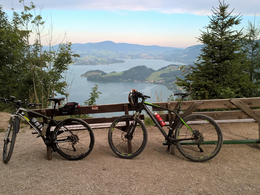
panoramic view: Great panorama
Paths covering:
unfixed, Hiking trail
powered by TOURDATA
Starting point is in Burgau...
.. the forest road until you reach the Moosalm. Keep right and take the trail to Unterackeralm and Oberackeralm up to Eisenaueralm. Take the forest road to Scharfling ( 17A), keep right (R2) at the Hauptstraße and on this road you go back to the starting point.
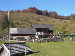
Refreshments: Eisenauer Alm (Buchberghütte) – Tel.: +43 6227 2405
+43 664 210 53 33
.. the forest road until you reach the Moosalm. Keep right and take the trail to Unterackeralm and Oberackeralm up to Eisenaueralm. Take the forest road to Scharfling ( 17A), keep right (R2) at the Hauptstraße and on this road you go back to the starting point.
Refreshments: Eisenauer Alm (Buchberghütte) – Tel.: +43 6227 2405
+43 664 210 53 33
details mountainbike
- Riding technique: medium

Accessibility / arrival
by car:
Coming from Salzburg via the A1 - exit Mondsee
Coming from Vienna/Linz via the A1 - exit St. Georgen, Attersee via Nußdorf to Unterach
Coming from the west - Bad Ischl-Weißenbach-Unterach
by train:
Coming from Salzburg or Linz/Vienna to Vöcklamarkt, then with the Attergau train to Attersee, and by bus to Unterach
by plane:
Coming from Salzburg via the A1 - exit Mondsee
Coming from Vienna/Linz via the A1 - exit St. Georgen
Other special suitabilities
trained hikers
Most economical season- Summer
Please get in touch for more information.

Hauptstraße 9
4866 Unterach am Attersee
Phone +43 7666 7719 - 50
Fax machine +43 7666 7719 - 59
E-Mail info.unterach@attersee.at
Web attersee-attergau.salzkammergut.at
https://attersee-attergau.salzkammergut.at
You can also visit us on
Visit us on Facebook Visit us on Instagram Visit us on Pinterest Visit our videochannel on YouTube WikipediaInteractive elevation profile
Create PDF
Tour-Details
Starting place: 4866 Unterach am Attersee
Destination: 4866 Unterach am Attersee
duration: 3h 18m
length: 26,3 km
Altitude difference (uphill): 1.238m
Altitude difference (downhill): 1.240m
Lowest point: 469m
Highest point: 1.040m
difficulty: difficult
condition: difficult
panoramic view: Great panorama
Paths covering:
unfixed, Hiking trail
powered by TOURDATA