

Königswiesen circuit tour M3


- Flatly
- Possible accommodation
Interactive elevation profile
Create PDF
Tour-Details
Path number: M3
Starting place: 4280 Königswiesen
Destination: 4280 Königswiesen
duration: 2h 43m
length: 27,9 km
Altitude difference (uphill): 929m
Altitude difference (downhill): 931m
Lowest point: 553m
Highest point: 870m
difficulty: difficult
condition: difficult
panoramic view: Great panorama
Paths covering:
Asphalt, Hiking trail
powered by TOURDATA
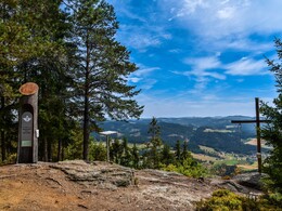
From the Königswiesen market place, the trails goes slightly uphill through the quiet and diverse landscape over the Reanakreuz (Reana cross), Schlag, the town of Salchenedt, Schreineredt, the Kaltenberg bridge, Moser Alm (Moser mountain pasture) to Kappermühle where you will cross the federal road. Further on to Kastendorf and Mötlasberg to the Wackelstein (balancing rock with an especially small contact surface, spheroidal weathering). A wonderful view awaits bikers there. The ascent to the summit cross 920 m above sea level, where you will be able to enjoy a view from the Schneeberg all the way to the Dachstein (ca. 10 minutes on foot), begins 200 metres after the junction with the Nordkamm state road on the left-hand side. From the Malerwinkel Katteneder (Katteneder painter’s corner), the trail goes mostly downhill back to the Königswiesen market place.
Starting point: Königswiesen market square
Destination: Königswiesen market square
further information:
- Flatly
- Possible accommodation
- Board possible
")
")
")
")
")
")
")
Accessibility / arrival
By car:
A7 Mühlkreisautobahn (Mühlkreis freeway) towards Freistadt - turn right onto the B124 Königswiesener Straße (Königswiesener Street) to Königswiesen
Most economical season
- Spring
- Summer
- Autumn
Please get in touch for more information.
4280 Königswiesen
Phone +43 7955 6255
Fax machine +43 7955 6255 - 32
E-Mail marktgemeinde@koenigswiesen.at
Web www.koenigswiesen.at
Web www.muehlviertleralm.at
http://www.koenigswiesen.at
http://www.muehlviertleralm.at
http://www.muehlviertleralm.at
Interactive elevation profile
Create PDF
Tour-Details
Path number: M3
Starting place: 4280 Königswiesen
Destination: 4280 Königswiesen
duration: 2h 43m
length: 27,9 km
Altitude difference (uphill): 929m
Altitude difference (downhill): 931m
Lowest point: 553m
Highest point: 870m
difficulty: difficult
condition: difficult
panoramic view: Great panorama
Paths covering:
Asphalt, Hiking trail
powered by TOURDATA