

Amon via ferrata


- Glacier region
Interactive elevation profile
Create PDF
Tour-Details
Paths covering:
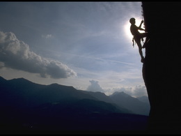
Description: Via ferrata only for experienced climbers with glacier experience
Dreamtour for every experienced alpine climber
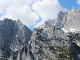
An outstanding alpine fixed rope route above the Große Gosaugletscher in the climbing area of the Adamek Hut at the NW-Face of the Hohes Kreuz mountain. The via ferrata starts trough shady and steep face and turns later to a beautiful ridge-route. Spectacular views into the glacier world of the Dachstein mountain range and the Hohe Dachstein accompany the climbers up to the 2837 m high summit of the Hohes Kreuz. A long alpine descent completes high-alpine ferrata. Depending on the day's destination and time you head down to the Adamek or Simony Hut. For fans of alpnine fixed rope routes definitely one of the best via ferrate routes in the Dachstein area, but it also requires appropriate alpine (glacier) experience!
For route details, topo and map see: https://www.bergsteigen.com/touren/klettersteig/amon-klettersteig-hohes-kreuz/
© www.bergsteigen.com
In case of emergency call the mountain rescue under 140
Download the via ferrata guide of Bad Goisern, Gosau at Dachstein, Hallstatt and Obertraun.
Experience a 360° panorama tour over Lake Gosau…
further information:
- Glacier region
Details - climbing mount
- difficulty acc. to Kurt Schall: very difficult (D)
- Hop off description: Coming from Lake Gosau first hike up to the Adamek hut, this steep and long trail prudently estimated takes about 4-5 hours. Then starting from Adamek hut shortly direction Dachstein, then straight ahead to the glacier nature trail and further onto the glacier to the north western wall of the Hohe Kreutz. The starting point is at a cave like niche below a steep water eroded wall.
- Hop on description: Starting from the summit of the Hohes Kreuz following the normal trail (marked but exposed) to the Niederes Kreuz and further to the Hoher Ochsenkogel. After that, down to the Hoher Trog (2 359 m). From here go either right hand side to the Simony hut (approx. 2 hours from the High Cross), which is closer, or left hand side back to the Adamek hut (approx. 4 hours).
- duration hop on: 6 h
- duration climbing mount: 2 h
- duration Descent: 8 h
June, July, August, September
by car
from Salzburg:
Motorway exit Golling via B162 Abtenau and B166 to Gosau
from Linz:
Motorway exit Regau on Salzkammergut street B145 towards Gmunden and Bad Ischl to Bad Goisern, in Bad Goisern turn right onto B166, at the Gosaumühle junction turn right towards Gosau
from Vienna/Graz:
Motorway exit Liezen on the B320, in Trautenfels turn on Salzkammergut street B145 to Bad Aussee, turn on Koppen street through Obertraun and Hallstatt, at the Gosaumühle junction turn left towards Gosau
from Villach:
Tauern motorway to exit “Eben im Pongau”, via the B166 Pass Gschütt federal road to Gosau
by train
Attnang-Puchheim - Stainach-Irdning lines
Arrival by train in "Steeg / Gosau" then continue with bus 541/542 in the direction Gosausee
By bus
Bus 470 (Abtenau - Gosau) direction Gosau, stop Gosau Abzw. Pass Gschütt
Bus 541/542 (Bad Ischl - Gosausee) direction Gosausee, stops Haltestelle: Gosau Klaushof, Gosau Bärnausiedlung, Gosau Ressenbachweg, Gosau Vordertal B166, Gosau Ramsau B166, Gosau, Gemeindeamt, Abzw. Pass Gschütt, Gosau Wirtsweg, Gosau Leitenweg, Gosau Schüttmannweg, Mittertal b. Gosau Ort, Mittertal, Hornspitzlift, Hintertal b. Gosau Falmbach, Hintertal b. Gosau Mühlradl, Hintertal b. Gosau Ort, Hintertal b. Gosau Madlgasse, Hintertal b. Gosau Schmiedweg, Hintertal b. Gosau Freilichtmuseum,Hintertal b. Gosau Zwieselalmbahn (Panoramajet), Hintertal b. Gosau Gosaukammbahn
Detailed information on the respective train and bus times can be found at https://www.oebb.at/en/ (train) and https://www.postbus.at/en(bus).
- Parking space: 200
- Parking area for disabled: 4
- Bus parking space: 4
parking free of charge
- Suitable for friends
- Suitable for couples
- Summer
Please get in touch for more information.
")
4824 Gosau
Phone +43 6135 6058
E-Mail gosau@dachstein-salzkammergut.at
Web www.outdoor-leadership.com/
You can also visit us on
Visit us on Facebook Visit us on Instagram Visit us on Pinterest Visit our videochannel on YouTube WikipediaInteractive elevation profile
Create PDF
Tour-Details
Paths covering: