

Outlaw Via Ferrata - Kleiner Krippenstein


- Glacier region
Interactive elevation profile
Create PDF
Tour-Details
Paths covering:
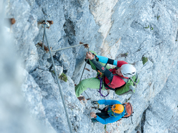
A short via ferrata in Obertraun with impressiv views on the Dachstein
Via ferrata close to the mountain station of the Dachstein Krippenstein cable car. During the whole tour you will have a beautitul view to the Dachstein.
Steep entry (B/C) then onto a rock ramp traversing (B) to an exposed corner (B). Farther on zigzag to a rock face (C). Then up to an easier karst area (A) further to an exposed travers with artificial footholds (B/C), then through ruff area to a vertical wall, which is secured with artificial holds again (C/D). After another exposed traverse the ascent leads into an easier karst area (B). The last step is quite steep (C) and ends at the summit of the small Krippenstein (B/A).
Important:
only with complete via ferrata set and helmet
In case of emergency call the mountain rescue under 140!
Download the via ferrata guide of Bad Goisern at Lake Hallstatt, Gosau at Dachstein, Hallstatt and Obertraun.
Experience a 360° panorama tour of the Dachstein Krippenstein…
further information:
- Glacier region
Details - climbing mount
- difficulty acc. to Kurt Schall: very difficult (D)
The via ferrata is accessible from May to October, depending on snow and weather conditions.
by car
from Salzburg:
Federal road B158 direction Bad Ischl
in Bad Ischl driveway onto Salzkammergut Straße B145 in direction to Bad Goisern, Hallstatt and Obertraun, in Obertraun turn right direction Dachstein Krippenstein cable car
from Linz:
A1 motorway exit Regau on Salzkammergut Straße B145 direction Gmunden, Bad Goisern, Hallstatt and Obertraun, in Obertraun turn right direction Dachstein Krippenstein cable car
from Graz:
A9 motorway exit Liezen on B320
in Trautenfels turn onto Salzkammergut Straße B145 via Bad Aussee to Obertraun, in Obertraun turn left direction Dachstein Krippenstein cable car
from Villach:
A10 Tauernautobahn to exit "Eben im Pongau", from there via Annaberg, Gosau and Hallstatt to Obertraun, in Obertraun turn right direction Dachstein Krippenstein cable car
by bus:
get off at the bus station “Obertraun Dachsteinseilbahn”
by train:
from Linz/Salzburg to Attnang-Puchheim, change to train to Stainach-Irdning
or from Stainach-Irdning Zug direction Attnang-Puchheim
get off at train station "Obertraun-Dachsteinhöhlen", from there 45 minutes to walk or change to the bus
Detailed information on the respective train and bus times can be found at https://www.oebb.at/en/ (train) and https://www.postbus.at/en(bus).
- Parking space: 200
- Parking area for disabled: 5
- Bus parking space: 12
parking free of charge
- Summer
Please get in touch for more information.
")
Winkl 34
4831 Obertraun
Phone +43 50 140
E-Mail obertraun@dachstein-salzkammergut.at
Web www.dachstein-salzkammergut.at
You can also visit us on
Visit us on Facebook Visit us on Instagram Visit us on Pinterest Visit our videochannel on YouTube WikipediaInteractive elevation profile
Create PDF
Tour-Details
Paths covering: