

Via Ferrata Alberfeldkogel - Feuerkogel


Interactive elevation profile
Create PDF
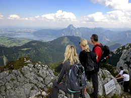
Tour-Details
Paths covering:
Route description:
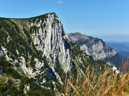
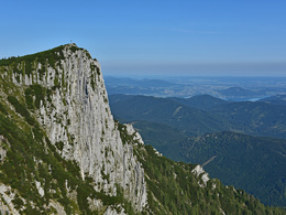
Set off from the Feuerkogel Bergstation (mountain station); firstly, take the hiking trail towards Alberfeldkogel peak. After approx. 45 minutes of walking, fork right (eastward) on very steep sloping terrain onto the climbing tracks.
WARNING: This is not a secured climb.
Please put on your climbing harness and helmet before embarking on this part. After approx. 300m you will reach the entry point beneath the Ostgrad of the Alberfeldkogel. The main difficulties are found in the lower section of the via ferrata; these diminish in the upper section. WARNING: In the upper part of the climb, you move directly above the entry; do not kick away any stones.
Climb-through:
410 climbing metres
Level of difficulty C
Helmet and harness with via ferrata safety set is absolutely essential!
Liability:
The builder, the market town of Ebensee, the land owner and the operator do not accept any liability for the safety of the facility and/or its usage. Any ascent is undertaken voluntarily and requires thorough planning and self-evaluation. Preparation, training and fitness are fundamental requirements. This via ferrata is not a beginner's course; it is a demanding tour of an alpine nature and therefore encompasses alpine hazards such as rockfall and adverse weather. Rescue is extremely difficult. Mobile phones only work at a few points.
further information:
- Board possible
Details - climbing mount
- difficulty acc. to Kurt Schall: difficult (C)
- duration hop on: 1 h
- duration climbing mount: 1 h
- duration Descent: 1 h
As a rule, in accordance with the summer operating times of the Feuerkogel cable car
from 8.30 am to 5pm.
As snowfields are often still present at the start of the summer season when ascending, the via ferrata can only be tackled from early/mid June at the earliest. It is then open daily until the end of October.
By car:
By car:
Westautobahn A1 Salzburg - Vienna, exit Regau --> B145 towards Ebensee
By train:
Westbahnstrecke 100 Salzburg - Vienna to Attnang-Puchheim --> on the Salzkammergut line 170 towards Stainach Irdning to Ebensee-Landungsplatz or Ebensee.
Mountain and valley trip on the Feuerkogel cable car as per price list. Please have a look at www.feuerkogel.info
Not suitable for inexperienced climbers, the ascent or rather descent from the hiking trail to the start of the via ferrata should be dry in any case (sloping terrain).
We recommend bringing your own footwear wird empfohlen, für das Klettern ein eigenes Paar Schuhe mit trockener Sohle mitzunehmen.
- Summer
- Autumn
Please get in touch for more information.
4802 Ebensee
Phone +43 6133 8016
mobile +46 676 83940703
E-Mail ebensee@traunsee-almtal.at
Web www.feuerkogel.info
Web www.traunsee-almtal.at/ebensee
http://www.traunsee-almtal.at/ebensee
Interactive elevation profile
Create PDF
Tour-Details
Paths covering: