

Long-distance trail Attersee-Attergau Stage 4 Steinbach - Seewalchen


- Multi-day tour
Interactive elevation profile
Create PDF
Tour-Details
Starting place: 4853 Steinbach am Attersee
Destination: 4863 Seewalchen am Attersee
duration: 11h 0m
length: 35,0 km
Altitude difference (uphill): 1.217m
Altitude difference (downhill): 1.212m
Lowest point: 469m
Highest point: 973m
difficulty: medium
condition: medium
panoramic view: Some Views
Paths covering:
Asphalt, Gravel, Hiking trail, Other
powered by TOURDATA
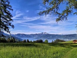
The 4th stage of the long-distance hiking trail Attersee-Attergau leads from Steinbach am Attersee over the Bramhosen into the Alexenau further to Weyregg. Via Brandsteig to the Gahberg further on to the Hongar. After the Alpenberg (973 m) it goes over the Loisenwies, Trattberg following the signs to Kammer-Schörfling over to Seewalchen am Attersee.
If this stage is too long for you (two mountains have to be crossed), you should plan another overnight stay in Weyregg. The Attersee circumnavigation is extended to five days.
From the tourist office in Steinbach am Attersee you set out to the nearby parish church. At the parish house (No 1) right behind the church, walk rightwards across the meadow and then left. That way, you arrive at the Seefeld community (472 m), where you take to the right to get to the sports centre and the Bierschmiede brewery. From there, follow the Großalm-Landesstraße for about 120 m into the valley until you turn left into the asphalted country road leading to Blümingen – you are now hiking up the Attersee-Ostwanderweg. From the upper meadows you continue on forest roads to the right on path No 1 passing below the tree nursery and then across a wooded ridge to arrive at a fork.
Take the right path for a short detour to a wooden sign in the middle of the forest indicating the summit Bramhosen (960 m) (in some maps also ‘Bramosen’). The path on the left takes you in northwestern direction into a forest and to the Seeleitenstüberl inn. From there, you walk down the path, which, further down, cuts short a forest road to Alexenau. To the left of the small settlement, there is the federal road and a bus stop. At the nearby lakeshore there is a pier of the boat service of Atterseeschifffahrt.
What follows is a flat stretch northwards on Dr.-Gleißner-Weg branching off on the right hand side – at first on gravel, then asphalt you walk through meadows and wooded slopes below Wachtberg and above the federal road. Enjoy the wonderful views over the lake and the Höllengebirge mountain range. In Weyregg turn left into Weyregger Straße before you get to the parish church. You arrive at the tourist office (No. 69) just before the restaurant Kaisergasthof Zur Post.
After crossing the street you continue along the lakeshore to the Lido (Strandbad), through Jubiläumsallee (parking) to the bridge across the Weyregger Bach stream and then straight ahead on a walkway to the northern end of the village. Before you reach the Guesthaus Staudinger (next to the restaurant Landeroith) you get back to Weyregger Straße on the right which you follow for about 350 metres to the plant shop Hemetsberger. There, you turn left into Plötzingerweg. The power line pole marks the beginning of the Brandsteig path, No. 5, up to the Gahberg mountain. It winds up to the Gahberg ridge through forested slopes and meadows passing by Brandnerhof. Terrific view across the lake and all the way to Schafberg mountain! Take to the right to pass by a farmhouse, continue on the asphalted access road taking you to the nearby Gahbergstraße which you follow leftwards across the entire ridge.
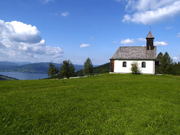
After a stretch of forest you pass by the observatory on Hintergahberg and the shingled Gahbergkapelle. A few metres further, you turn left into the marked hiking path to Kreuzingalm. It runs across the ridge to Schickermahd, passing Kreuzingalm inn (short but rewarding detour). About 3 km after the alpine pasture, you corss the forested Alpenberg and after a short descent you arrive at a fork, where a representation of St. Mary commemorates a bomb attack in 1945. Continue straight ahead and after the ‘Hongar‘ sign you reach the alpine inn Schwarz.
Walk back along the forested ridge to the fork and the representation of St. Mary. After the sign ‘Looh, Halbmoos‘ walk down the path and on rugged forest roads (No. 6) through the forested northern side of Alpenberg to the idyllic Loitzenwies (hunter’s house). Arriving there, you turn left and cross the wooded ridge of the Schörflinger Trattberg mountain on forest road No 3 until you get to the neighbourhood Oberhehenfeld am Sickingbach. The country inn Schneiderwirt will be happy to help you regain strength.
Walk left on the asphalted Sickinger Straße into the valley passing by the fire department and the renovated Poinerhaus building. At the next junction, take to the right onto Bachbauernstraße, then Marktwaldstraße across a forested saddle (560 m). When you get to open meadows, turn left towards Waldvilla. There, you turn right into Karl-Hausjell-Allee. Cross the bridge over the bypass road and continue into Kammer-Schörfling. The tourist office is in Hauptstraße (No. 7). Continue to the right across the bridge over Ager river and turn left into Seewalchen am Attersee.
Indications regarding public transport:
• Water taxi Attersee - for Information click here!
• Attergau railway from Attersee am Attersee to St. Georgen im Attergau
• Bus connection from Seewalchen am Attersee to Nußdorf - Bus number 564
• Attersee Schifffahrt from Seewalchen to Attersee and on to Nußdorf
Find all the details on ships, train and bus here!
If this stage is too long for you (two mountains have to be crossed), you should plan another overnight stay in Weyregg. The Attersee circumnavigation is extended to five days.
From the tourist office in Steinbach am Attersee you set out to the nearby parish church. At the parish house (No 1) right behind the church, walk rightwards across the meadow and then left. That way, you arrive at the Seefeld community (472 m), where you take to the right to get to the sports centre and the Bierschmiede brewery. From there, follow the Großalm-Landesstraße for about 120 m into the valley until you turn left into the asphalted country road leading to Blümingen – you are now hiking up the Attersee-Ostwanderweg. From the upper meadows you continue on forest roads to the right on path No 1 passing below the tree nursery and then across a wooded ridge to arrive at a fork.
Take the right path for a short detour to a wooden sign in the middle of the forest indicating the summit Bramhosen (960 m) (in some maps also ‘Bramosen’). The path on the left takes you in northwestern direction into a forest and to the Seeleitenstüberl inn. From there, you walk down the path, which, further down, cuts short a forest road to Alexenau. To the left of the small settlement, there is the federal road and a bus stop. At the nearby lakeshore there is a pier of the boat service of Atterseeschifffahrt.
What follows is a flat stretch northwards on Dr.-Gleißner-Weg branching off on the right hand side – at first on gravel, then asphalt you walk through meadows and wooded slopes below Wachtberg and above the federal road. Enjoy the wonderful views over the lake and the Höllengebirge mountain range. In Weyregg turn left into Weyregger Straße before you get to the parish church. You arrive at the tourist office (No. 69) just before the restaurant Kaisergasthof Zur Post.
After crossing the street you continue along the lakeshore to the Lido (Strandbad), through Jubiläumsallee (parking) to the bridge across the Weyregger Bach stream and then straight ahead on a walkway to the northern end of the village. Before you reach the Guesthaus Staudinger (next to the restaurant Landeroith) you get back to Weyregger Straße on the right which you follow for about 350 metres to the plant shop Hemetsberger. There, you turn left into Plötzingerweg. The power line pole marks the beginning of the Brandsteig path, No. 5, up to the Gahberg mountain. It winds up to the Gahberg ridge through forested slopes and meadows passing by Brandnerhof. Terrific view across the lake and all the way to Schafberg mountain! Take to the right to pass by a farmhouse, continue on the asphalted access road taking you to the nearby Gahbergstraße which you follow leftwards across the entire ridge.
After a stretch of forest you pass by the observatory on Hintergahberg and the shingled Gahbergkapelle. A few metres further, you turn left into the marked hiking path to Kreuzingalm. It runs across the ridge to Schickermahd, passing Kreuzingalm inn (short but rewarding detour). About 3 km after the alpine pasture, you corss the forested Alpenberg and after a short descent you arrive at a fork, where a representation of St. Mary commemorates a bomb attack in 1945. Continue straight ahead and after the ‘Hongar‘ sign you reach the alpine inn Schwarz.
Walk back along the forested ridge to the fork and the representation of St. Mary. After the sign ‘Looh, Halbmoos‘ walk down the path and on rugged forest roads (No. 6) through the forested northern side of Alpenberg to the idyllic Loitzenwies (hunter’s house). Arriving there, you turn left and cross the wooded ridge of the Schörflinger Trattberg mountain on forest road No 3 until you get to the neighbourhood Oberhehenfeld am Sickingbach. The country inn Schneiderwirt will be happy to help you regain strength.
Walk left on the asphalted Sickinger Straße into the valley passing by the fire department and the renovated Poinerhaus building. At the next junction, take to the right onto Bachbauernstraße, then Marktwaldstraße across a forested saddle (560 m). When you get to open meadows, turn left towards Waldvilla. There, you turn right into Karl-Hausjell-Allee. Cross the bridge over the bypass road and continue into Kammer-Schörfling. The tourist office is in Hauptstraße (No. 7). Continue to the right across the bridge over Ager river and turn left into Seewalchen am Attersee.
Indications regarding public transport:
• Water taxi Attersee - for Information click here!
• Attergau railway from Attersee am Attersee to St. Georgen im Attergau
• Bus connection from Seewalchen am Attersee to Nußdorf - Bus number 564
• Attersee Schifffahrt from Seewalchen to Attersee and on to Nußdorf
Find all the details on ships, train and bus here!
Starting point: Steinbach am Attersee - Village Square
Destination: Seewalchen am Attersee - Church
further information:
- Multi-day tour


Accessibility / arrival
Car:
- From Vienna/Linz via the A1 - Schörfling am Attersee exit - then another 17 km via the B 152 Weyregg am Attersee to Steinbach am Attersee.
- From Salzburg via A1 - exit Mondsee - then another 25 km via Unterach am Attersee - Weißenbach am Attersee to Steinbach am Attersee
- From the north via the A8 - Ried exit - to the town of Ried approx. 4 km, then another 60 km via Frankenburg - Gampern - Schörfling am Attersee - Weyregg am Attersee to Steinbach am Attersee
- From the south via Bad Ischl - from Bad Ischl there are still 25 km - after about 4 km turn left - across Weißenbachtal to Attersee - in Weißenbach am Attersee turn right to Steinbach am Attersee
By train:
Coming from Vienna/Linz/Wels to Vöcklabruck or Attnang-Puchheim and continue by bus or cab to Steinbach am Attersee.
From Salzburg to Vöcklabruck or Attnang-Puchheim and continue by bus or cab to Steinbach am Attersee or alternatively Vöcklamarkt train station and take the Attergaubahn to Attersee - continue by boat to Steinbach am Attersee
- Suitable for groups
- Suitable for teenagers
- Suitable for single travelers
- Suitable for friends
- Suitable for couples
- Spring
- Summer
- Autumn
Please get in touch for more information.
Attergaustraße 55
4880 St. Georgen im Attergau
Phone +43 7666 7719 - 0
E-Mail info@attersee.at
Web attersee-attergau.salzkammergut.at
https://attersee-attergau.salzkammergut.at
You can also visit us on
Visit us on Facebook Visit us on Instagram Visit us on Pinterest Visit our videochannel on YouTube")
")
")
")
Interactive elevation profile
Create PDF
Tour-Details
Starting place: 4853 Steinbach am Attersee
Destination: 4863 Seewalchen am Attersee
duration: 11h 0m
length: 35,0 km
Altitude difference (uphill): 1.217m
Altitude difference (downhill): 1.212m
Lowest point: 469m
Highest point: 973m
difficulty: medium
condition: medium
panoramic view: Some Views
Paths covering:
Asphalt, Gravel, Hiking trail, Other
powered by TOURDATA