

From Winkl to mount Schafberg (Sheepmountain)


Interactive elevation profile
Create PDF
Tour-Details
Starting place: 5310 Tiefgraben am Mondsee
Destination: 5310 Tiefgraben am Mondsee
duration: 5h 30m
length: 12,3 km
Altitude difference (uphill): 1.325m
Altitude difference (downhill): 1.317m
Lowest point: 580m
Highest point: 1.758m
difficulty: difficult
condition: difficult
panoramic view: Dreamtour
Paths covering:
Gravel, Hiking trail
powered by TOURDATA
The easiest way to climb the Schafberg (sheep mountain).
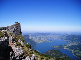
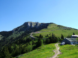
From the Winkl fire brigade, we follow the signs for hiking trail no. 20 in the direction of the Schafbergalm. When we arrive at the Alm, we have already completed two hours of hiking and can take a short break. There is the option of continuing to hike the last stage along hiking trail no. 20 to the Schafbergspitze or having the Schafbergbahn take you to the summit (note: the seats on the cable car are often fully booked!). Arrived at the summit, we enjoy the wonderful view over the Salzkammergut, with good visibility we can see as far as the Dachstein. For the descent we take the same path as for the ascent.
Refreshments: "Hotel Schafbergspitze" and shelter "Himmelspforte".
The times given correspond to the outward and return journey.
Refreshments: "Hotel Schafbergspitze" and shelter "Himmelspforte".
The times given correspond to the outward and return journey.
Starting point: Parking lot fire station Winkl
Destination: Peak of mount Schafberg
further information:
- Board possible
Accessibility / arrival
The starting point of this tour is the depot of the Winkl volunteer fire brigade, located directly on the B154.
- Parking space: 20
none
- Suitable for teenagers
- Suitable for single travelers
- Suitable for friends
- Suitable for couples
- Summer
- Autumn
Please get in touch for more information.
Dr. Franz Müller Straße 3
5310 Mondsee am Mondsee
Phone +43 6232 2270
Fax machine +43 6232 2270 - 22
E-Mail info@mondsee.at
Web www.mondsee.at
http://www.mondsee.at
Interactive elevation profile
Create PDF
Tour-Details
Starting place: 5310 Tiefgraben am Mondsee
Destination: 5310 Tiefgraben am Mondsee
duration: 5h 30m
length: 12,3 km
Altitude difference (uphill): 1.325m
Altitude difference (downhill): 1.317m
Lowest point: 580m
Highest point: 1.758m
difficulty: difficult
condition: difficult
panoramic view: Dreamtour
Paths covering:
Gravel, Hiking trail
powered by TOURDATA