

Schafberg - option 1 = via Mühlleiten


- culinary interesting
- Possible accommodation
Interactive elevation profile
Create PDF
Tour-Details
Starting place: 4866 Unterach am Attersee
Destination: 4866 Unterach am Attersee
duration: 6h 18m
length: 14,0 km
Altitude difference (uphill): 1.321m
Altitude difference (downhill): 101m
Lowest point: 479m
Highest point: 1.699m
difficulty: difficult
condition: very difficult
panoramic view: Dreamtour
Paths covering:
Gravel, Hiking trail, Other
powered by TOURDATA
Schafberg - option 1 = via Mühlleiten
Schafberg hike via Mühlleiten
In order to reach Mount Schafberg, you don't need to start in St. Wolfgang. You can also scale Mount Schafberg from Unterach.
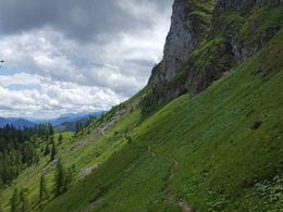
You start at the bridge in Mühlleiten. from there, you continue on following the forest trail and turn left at the next crossing. After about 20 - 30 minutes, you cross the forest road (Forststraße). Afterwards you hike several serpentines to the Eisenaueralm (mountain pasture). The mountain pasture is situated at about 1000 m altitude. To your right you will find the cabine "Buchberghütte".
Behind the cabin, a trail to the right leads up into the forest.
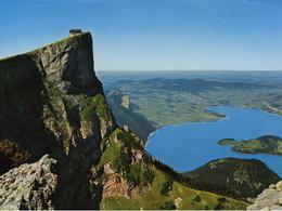
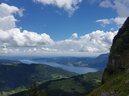
After about 45 - 70 minutes, you finally arrive at the mountain gorge at the scenic Lake Suissensee. From there, you take the trail on the left and hike along the steep Purtscheller track to the Schafberg lakes. Now, you are almost at the peak of Mount Schafberg. Enjoy the fantastic view of Lake Attersee from an altitude of 1782 m and prepare yourself for the descent with refreshments from the Himmelspforthütte.
Schafberg hike via Mühlleiten
In order to reach Mount Schafberg, you don't need to start in St. Wolfgang. You can also scale Mount Schafberg from Unterach.
You start at the bridge in Mühlleiten. from there, you continue on following the forest trail and turn left at the next crossing. After about 20 - 30 minutes, you cross the forest road (Forststraße). Afterwards you hike several serpentines to the Eisenaueralm (mountain pasture). The mountain pasture is situated at about 1000 m altitude. To your right you will find the cabine "Buchberghütte".
Behind the cabin, a trail to the right leads up into the forest.
After about 45 - 70 minutes, you finally arrive at the mountain gorge at the scenic Lake Suissensee. From there, you take the trail on the left and hike along the steep Purtscheller track to the Schafberg lakes. Now, you are almost at the peak of Mount Schafberg. Enjoy the fantastic view of Lake Attersee from an altitude of 1782 m and prepare yourself for the descent with refreshments from the Himmelspforthütte.
Starting point: Mühlleiten in Unterach
Destination: Schafbergspitze
further information:
- culinary interesting
- Possible accommodation
- Experience of nature
- Board possible


Accessibility / arrival
by car:
Coming from Salzburg via the A1 - exit Mondsee
Coming from Vienna/Linz via the A1 - exit St. Georgen, Attersee via Nußdorf to Unterach
Coming from the west - Bad Ischl-Weißenbach-Unterach
by train:
Coming from Salzburg or Linz/Vienna to Vöcklamarkt, then with the Attergau train to Attersee, and by bus to Unterach
by plane:
Coming from Salzburg via the A1 - exit Mondsee
Coming from Vienna/Linz via the A1 - exit St. Georgen
- Suitable for single travelers
- Suitable for friends
- Suitable for couples
for trained hikers
Most economical season- Summer
Please get in touch for more information.
Hauptstraße 9
4866 Unterach am Attersee
Phone +43 7666 7719 - 50
E-Mail info.unterach@attersee.at
Web attersee-attergau.salzkammergut.at
https://attersee-attergau.salzkammergut.at
You can also visit us on
Visit us on Facebook Visit us on Instagram Visit us on Pinterest Visit our videochannel on YouTube WikipediaInteractive elevation profile
Create PDF
Tour-Details
Starting place: 4866 Unterach am Attersee
Destination: 4866 Unterach am Attersee
duration: 6h 18m
length: 14,0 km
Altitude difference (uphill): 1.321m
Altitude difference (downhill): 101m
Lowest point: 479m
Highest point: 1.699m
difficulty: difficult
condition: very difficult
panoramic view: Dreamtour
Paths covering:
Gravel, Hiking trail, Other
powered by TOURDATA