

Hinterstoder-Vorderstoder circular tour


- Flatly
Interactive elevation profile
Create PDF
Tour-Details
Path number: 201,9,35
Starting place: 4573 Hinterstoder
Destination: 4573 Hinterstoder
duration: 5h 10m
length: 15,9 km
Altitude difference (uphill): 613m
Altitude difference (downhill): 613m
Lowest point: 578m
Highest point: 823m
difficulty: medium
condition: medium
panoramic view: Some Views
Paths covering:
Asphalt, Gravel, Hiking trail
powered by TOURDATA
CAUTION:
The trails No. 201 and No. 1 is blocked (Hinterstoder Vorderstoder about Wartegg / Panoramarunde) between Wartegg and Baderau / access road Bärensimmerl for timber extraction work from 11.11. until 30.11.2013.
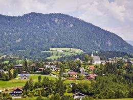
From the center of Hinterstoder you hike the loop trail to Vorderstoder and back to Hinterstoder! Starting from the Alpineum in Hinterstoder walk to Auweg Nr. 1 to the country inn GH Jaidhaus, at the turn off to the toll road follow trail nr. 201 to the country hotel Landhotel Gressenbauer and continue along the old toll road leading uphills and turn left at a bend at the edge of the forest to the Warteggergut estate. Turn left (follow the signs „Stodertaler Winterwanderweg“, or the mountainbike route) along a gravel road through forest and meadows via the Luckerbauerbacherl (farm) to the Knittelgraben, continue uphills, then turn left onto a gravel road to the Hutgrabner and Hackl farms with stunning views to Vorderstoder. Either walk directly into the village for another 15 min., or continue to follow the signs of the winter hiking trail leading you through a range of farms to the Schaffergut farm and then into the village (about ½ hr extra walk). In the village pass the Steinerwirt guesthouse and turn right downhills onto trail nr. 9 via Zamsegg onto a tar road for a short while, then left onto a gravel road and later onto a footpath to the Lugis farm. Continue along either trail nr. 35 via the Stensberg mountain and Schmiedleithen back onto the main country road (pedestrian path) back to Hinterstoder, or continue on trail nr. 9 to get to the Strumboding-Waterfall and back to Hinterstoder.
Trail-Nr: 201, 9, 35
The trails No. 201 and No. 1 is blocked (Hinterstoder Vorderstoder about Wartegg / Panoramarunde) between Wartegg and Baderau / access road Bärensimmerl for timber extraction work from 11.11. until 30.11.2013.
From the center of Hinterstoder you hike the loop trail to Vorderstoder and back to Hinterstoder! Starting from the Alpineum in Hinterstoder walk to Auweg Nr. 1 to the country inn GH Jaidhaus, at the turn off to the toll road follow trail nr. 201 to the country hotel Landhotel Gressenbauer and continue along the old toll road leading uphills and turn left at a bend at the edge of the forest to the Warteggergut estate. Turn left (follow the signs „Stodertaler Winterwanderweg“, or the mountainbike route) along a gravel road through forest and meadows via the Luckerbauerbacherl (farm) to the Knittelgraben, continue uphills, then turn left onto a gravel road to the Hutgrabner and Hackl farms with stunning views to Vorderstoder. Either walk directly into the village for another 15 min., or continue to follow the signs of the winter hiking trail leading you through a range of farms to the Schaffergut farm and then into the village (about ½ hr extra walk). In the village pass the Steinerwirt guesthouse and turn right downhills onto trail nr. 9 via Zamsegg onto a tar road for a short while, then left onto a gravel road and later onto a footpath to the Lugis farm. Continue along either trail nr. 35 via the Stensberg mountain and Schmiedleithen back onto the main country road (pedestrian path) back to Hinterstoder, or continue on trail nr. 9 to get to the Strumboding-Waterfall and back to Hinterstoder.
Trail-Nr: 201, 9, 35
Starting point: Center (tourist office) in Hinterstoder
Destination: Center (tourist office) in Hinterstoder
further information:
- Flatly
- Board possible
Accessibility / arrival
The starting point is the tourist office in the center of Hinterstoder.
Parking large car park at the beginning or the parking lot at the Hösshalle (fees apply).
Parking fees Parking Hösshalle: to 4 hours € 2.00 to 1 day € 3,00 2 to max. 7 days € 5.00 Annual ticket € 20.00
Most economical season
- Spring
- Summer
- Autumn
Please get in touch for more information.

Hinterstoder 38
4573 Hinterstoder
Phone +43 7564 5263
Fax machine +43 7564 5263 - 30
E-Mail hinterstoder@pyhrn-priel.net
Web www.urlaubsregion-pyhrn-priel.at
https://www.urlaubsregion-pyhrn-priel.at
Interactive elevation profile
Create PDF
Tour-Details
Path number: 201,9,35
Starting place: 4573 Hinterstoder
Destination: 4573 Hinterstoder
duration: 5h 10m
length: 15,9 km
Altitude difference (uphill): 613m
Altitude difference (downhill): 613m
Lowest point: 578m
Highest point: 823m
difficulty: medium
condition: medium
panoramic view: Some Views
Paths covering:
Asphalt, Gravel, Hiking trail
powered by TOURDATA