

Tour around the Gosaukamm


- Flatly
Interactive elevation profile
Create PDF
Tour-Details
Paths covering:
Uniquely scenic two-day tour around a wildly rugged mountain range. Well-maintained, but in places rocky and exposed paths, some of which are secured for short passages.
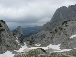
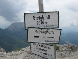
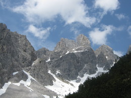
The tour around the Gosaukamm is a "classic" among alpine high-altitude trails. Gentle and rugged are often just a stone's throw away from each other here. Probably the most beautiful part of this tour is reached on the Steiglpass, where you come very close to the strikingly shaped Bischofsmütze. Since 1993, the highest mountain in the Gosaukamm range has lost large parts of its south and east face - the yellow demolition area, which is a reminder of this landslide of the century, still sends volleys of rockfall into the depths. We first hike from the cable car station to the nearby Gablonzer Hütte and on to the fork in the trail at Unterer Törlecksattel. Follow the Austriaweg trail downhill to the right through rocky grassy slopes and a section of forest to the Stuhlalm (the nearby Theodor-Körner-Hütte is hidden in the forest). Cross the grassy ridge above the alp (Mooseben) into the mountain pine-covered Grubach below the Stuhlloch and through a narrow gorge ("passage") made passable with wooden steps and steel cable up to the Jöchl. Then almost flat under the rocky foothills of the Bischofsmütze (steel cables) to the Mahdalmriegel, there to the left and through the wide grass and scree slopes above the Sulzkar and Retteneggalm to the Hofpürglhütte, which is already visible from afar. Continue along the Linzer Weg (No. 612 or 601) into the huge scree basin below the Bischofsmütze. Turn left there, through the slope to the foot of the wall and over exposed rocky ledges secured with steel cables to the Steiglpass. On the north side, the climbing trail leads down through stepped karst terrain into the rocky high valley between the Großwand and the Kopfwand. Through the ice pit into the Ahornkar covered in mountain pines and - past the Weitgries - to the Hintere Scharwandalm (memorial). Via a steeper forest slope we reach a historic hunting lodge and through the outlet of the Gamsriese filled with debris to the Scharwandhütte below. Descend along the sloping forest ramp above the Vordere Scharwand, turn right at the next fork in the path and through the scree field below the Strichkogel to the Seeklausalm at the Vordere Gosausee. Turn right over the dam wall to the inn or to the cable car valley station.
Order hiking maps for the Dachstein Salzkammergut region ...
Experience a 360° panorama tour through Gosau valley…
Mountain rescue: 140
further information:
- Flatly
This hiking trail is, depending on the weather, accessible from June till September.
by car
from Salzburg:
Motorway exit Golling via B162 Abtenau and B166 to Gosau
from Linz:
Motorway exit Regau on Salzkammergut street B145 towards Gmunden and Bad Ischl to Bad Goisern, in Bad Goisern turn right onto B166, at the Gosaumühle junction turn right towards Gosau
from Vienna/Graz:
Motorway exit Liezen on the B320, in Trautenfels turn on Salzkammergut street B145 to Bad Aussee, turn on Koppen street through Obertraun and Hallstatt, at the Gosaumühle junction turn left towards Gosau
from Villach:
Tauern motorway to exit “Eben im Pongau”, via the B166 Pass Gschütt federal road to Gosau
by train
Attnang-Puchheim - Stainach-Irdning lines
Arrival by train in "Steeg / Gosau" then continue with bus 542 in the direction Gosausee
By bus
Bus 470 (Abtenau - Gosau) direction Gosau, stop Gosau Abzw. Pass Gschütt
Bus 542 (Bad Ischl - Gosausee) direction Gosausee, stops Haltestelle: Gosau Klaushof, Gosau Bärnausiedlung, Gosau Ressenbachweg, Gosau Vordertal B166, Gosau Ramsau B166, Gosau, Gemeindeamt, Abzw. Pass Gschütt, Gosau Wirtsweg, Gosau Leitenweg, Gosau Schüttmannweg, Mittertal b. Gosau Ort, Mittertal, Hornspitzlift, Hintertal b. Gosau Falmbach, Hintertal b. Gosau Mühlradl, Hintertal b. Gosau Ort, Hintertal b. Gosau Madlgasse, Hintertal b. Gosau Schmiedweg, Hintertal b. Gosau Freilichtmuseum,Hintertal b. Gosau Zwieselalmbahn (Panoramajet), Hintertal b. Gosau Gosaukammbahn
Detailed information on the respective train and bus times can be found at https://www.oebb.at/en/ (train) and https://www.postbus.at/en(bus).
- Parking space: 200
- Parking area for disabled: 4
- Bus parking space: 4
no parking fees
- Suitable for groups
- Suitable for friends
- Suitable for couples
- Summer
- Autumn
Please get in touch for more information.

Gosauseestraße 5
4824 Gosau
Phone +43 5 95095 - 20
Fax machine +43 5 95095 - 34
E-Mail gosau@dachstein-salzkammergut.at
Web www.dachstein-salzkammergut.at
You can also visit us on
Visit us on Facebook Visit us on Instagram Visit us on Pinterest Visit our videochannel on YouTube Wikipedia")
Interactive elevation profile
Create PDF
Tour-Details
Paths covering: