

Tour to the Top of the Kalmberg


- pets allowed
Interactive elevation profile
Create PDF
Tour-Details
Paths covering:
It´s a Scenic mountain hike on a commanding summit! Good, but in places different ways and paths.
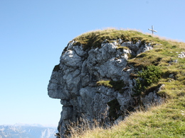
Now our path climbs steeply through the forest and cuts off two roads; then we follow the forest road into a high valley. Soon we leave the track to the right and march on the old alpine path through rustic forest to the Schartenalm and up into a small saddle. On the left you will reach the Goiserer hut with a few steps. To the right of the saddle, on the other hand, is the summit platform No. 888. We follow it to the south, cross the hillside in front of the Kalmoskirche (cave) and climb the Hochkalmberg over a mountain pine ridge - past the contemplative face of the "Kalmberg-Indianers", which a mood of nature has modeled out of the summit rock. Descent on the same route.
Rest options:
Iglmoosalm, Goiserer hut
Experience a 360° panorama tour through Gosau valley...
Mountain Rescue: 140
further information:
- Board possible
This hiking trail is, depending on the weather, accessible from May till October. In winter you can reach the Goisererhut and the Kalmberg with skis or snowshoes.

by car
from Salzburg:
Motorway exit Golling via B162 Abtenau and B166 to Gosau
from Linz:
Motorway exit Regau on Salzkammergut street B145 towards Gmunden and Bad Ischl to Bad Goisern, in Bad Goisern turn right onto B166, at the Gosaumühle junction turn right towards Gosau
from Vienna/Graz:
Motorway exit Liezen on the B320, in Trautenfels turn on Salzkammergut street B145 to Bad Aussee, turn on Koppen street through Obertraun and Hallstatt, at the Gosaumühle junction turn left towards Gosau
from Villach:
Tauern motorway to exit “Eben im Pongau”, via the B166 Pass Gschütt federal road to Gosau
by train
Attnang-Puchheim - Stainach-Irdning lines
Arrival by train in "Steeg / Gosau" then continue with bus 542 in the direction Gosausee
By bus
Bus 470 (Abtenau - Gosau) direction Gosau, stop Gosau Abzw. Pass Gschütt
Bus 542 (Bad Ischl - Gosausee) direction Gosausee, stops Haltestelle: Gosau Klaushof, Gosau Bärnausiedlung, Gosau Ressenbachweg, Gosau Vordertal B166, Gosau Ramsau B166
Detailed information on the respective train and bus times can be found at https://www.oebb.at/en/ (train) and https://www.postbus.at/en(bus).
- Parking space: 50
Price according to the notice board
The hiking trail is freely accessible.
Please note that fees apply for the nearby car park at the Schlosspark.
- Suitable for groups
- Suitable for kids (6 - 14 Year)
- Pets allowed
- Suitable for friends
- Suitable for couples
- Summer
- Autumn
Please get in touch for more information.

Gosauseestraße 5
4824 Gosau
Phone +43 5 95095 - 20
Fax machine +43 5 95095 - 74
E-Mail gosau@dachstein-salzkammergut.at
Web www.dachstein-salzkammergut.at
You can also visit us on
Visit us on Facebook Visit us on Instagram Visit us on Pinterest Visit our videochannel on YouTube WikipediaInteractive elevation profile
Create PDF
Tour-Details
Paths covering: