

Hiking trail to the "Hütteneckalm"


- Suitable for families
Interactive elevation profile
Create PDF
Tour-Details
Paths covering:
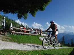
Hike to the “Hütteneckalm” in the Predigstuhl Area
The 1.5 hour hike starts at the parking lot Predigstuhl, which is easily accessible by car via the toll-free panoramic road, but can also be hiked in about 1.5 hours from the center of Bad Goisern.
Below the former Predigstuhl Inn turn right into the forest and after about 50 m left on the forest road. After another approx. 200 m we have to turn right again, following the signs towards “Roßmoosalm”. The path now goes slightly up through the forest until we reach the “Roßmoosalm” after about 30 minutes. When crossing the lush meadows, we can already catch the first views of the Dachstein glacier and the surrounding mountain ranges.
At the top of the meadow we reach a forest road which we follow to the right until we reach another junction. Here we follow the left path, which now goes a little steeper up into the forest. We follow the path through the forest which leads past the path going to the “Outdoor Leadership climbing area” until we have reached the “Zwerchwand” quarry. Here you have a breathtaking view over the Goiserer valley, Lake Hallstatt to the Dachstein.
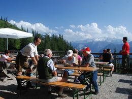
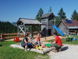
Now it goes along a narrow path through the quarry, which triggers enthusiasm especially among children, because you can climb on the small and large boulders. After we have crossed the quarry, most of the hike is done, from here it takes about 15 minutes until we have reached the “Hütteneckalm”. In the Hütteneck hut at 1,240 m above sea level, we can expect a breathtaking view of the world heritage with the Dachstein and its glacier, as well as culinary delight from the traditional wood-burning oven. Also there is a playground and a petting zoo for children.
For the way back you can choose the same route or the descent towards St. Agatha.
The “Zwerchwand” quarry
The “Zwerchwand” quarry is not only interesting for children who like to climb, it is also a treasure trove for geologically interested people. But where did the quarry come from?
On October 15, 1978, around 6:15 p.m., there was a heavy landslide directly over the hiking trail, which buried about 100 m of the trail with 50,000 to 60,000 m³ of rocks. Already around 3:30 p.m. unsuspecting hikers could hear the crack in the wall and the first small rocks came off. The actual landslide was heard by the residents of “Hütteneck” and “Pichlern” as a violent crash and thunder, whereby the farms in the immediate continuation of the crash direction also felt a tremendous shock.
Since then, the south side of the “Zwerchwand” has not come to rest. In 1983, even larger rocks than before came down. Since this rock fall there is also a so-called Mini Matterhorn with summit cross, which bears the name due to its very similar appearance to the original.
More hiking opportunities
Not only the hike to the “Hütteneckalm” invites you into the nature of the world heritage. The demanding hike to the summit of the Predigstuhl or the easy and leisurely hike along the tolerance path is also worth a trip. The legend trail is definitely a must do for children who visit Bad Goisern.
More recommendations for hiking trails you can find in our overview of all hiking trails in the Holiday Region Dachstein Salzkammergut.
In emergency call the mountain rescue 140
Hike already now online through Bad Goisern in the 360 ° panorama tour..
further information:
- Board possible
The Hütteneck hut is open from May 16th to October 26th.
Closed on Mondays and Tuesdays!
In Bad Goisern on the B 145 drive in the roundabout and take the exit towards Predigstuhl. Along the toll-free panoramic road, you head towards the Predigstuhl. A free parking space is available here.
Parking- Parking space: 30
- Bus parking space: 2
free of charge
- Suitable for groups
- Suitable for schools
- Suitable for seniors
- Suitable for single travelers
- Suitable for friends
- Suitable for couples
- Suitable for children
- Summer
- Autumn
Please get in touch for more information.
Kirchengasse 4
4822 Bad Goisern am Hallstättersee
Phone +43 5 95095 - 10
Fax machine +43 5 95095 - 74
E-Mail goisern@dachstein-salzkammergut.at
Web www.wandern-dachstein.at
Web www.dachstein-salzkammergut.at
http://www.dachstein-salzkammergut.at
You can also visit us on
Visit us on Facebook Visit us on Instagram Visit us on Pinterest Visit our videochannel on YouTube Wikipedia Blog")
")
")
Interactive elevation profile
Create PDF
Tour-Details
Paths covering: