

Koloman's hill round track


- Suitable for families
- Flatly
Interactive elevation profile
Create PDF
Tour-Details
Starting place: 5310 Tiefgraben am Mondsee
Destination: 5310 Tiefgraben am Mondsee
duration: 2h 41m
length: 6,3 km
Altitude difference (uphill): 423m
Altitude difference (downhill): 426m
Lowest point: 724m
Highest point: 1.082m
difficulty: medium
condition: medium
panoramic view: Individual Views
Paths covering:
Hiking trail
powered by TOURDATA
roadblock: Akutmeldung/Sperre
Description:
ATTENTION WALKBOCKS!
Unfortunately, at the moment only the path from the Kolomanskirche to the Hochserner snack station is freely accessible - the path from the Kolomanstaferl to the Hochserner is not passable due to large amounts of damaged wood !!! As of Sept. 09th 2022
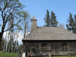
Follow the tracks of the wood grouse to the oldest wooden church in Austria.
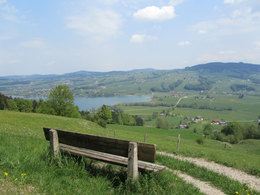
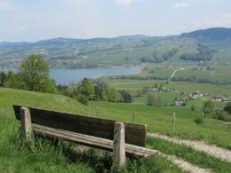
We start at the restaurant "Hochserner" where we are able to enjoy the first impressing views over the Mondsee and Irrsee lakes. At the former mountain station of the ski lift we turn left into the forest. Now it takes us about one hour of slight increase through a natural wood until we reach the St. Koloman church. At the summit we find as well the Koloman spring. Its water helps against eye diseases. On the summit we find as well two radar stations from the Austrian military. Please note that you must not enter the prohibited area.
Use the same way back until you reach a crossing in the middle of the forest but do not turn right but follow all the way long till you reach the Koloman panel. Follow the way back to the starting point.
Starting point: Hochserner snack station above the Irrsee.
Destination: Hochserner snack station above the Irrsee.
further information:
- Flatly
- Board possible
")
")
Accessibility / arrival
Our tour starts at the Hochserner snack station above the Irrsee.
- Parking space: 20
A stop at the Hochserner snack station is welcome!
- Suitable for groups
- Suitable for seniors
- Suitable for single travelers
- Suitable for friends
- Suitable for couples
- Spring
- Summer
- Autumn
- Early winter
Please get in touch for more information.
Dr. Franz Müller Straße 3
5310 Tiefgraben am Mondsee
Phone +43 6232 2270
Fax machine +43 6232 2270 - 22
E-Mail info@mondsee.at
Web www.mondsee.at
http://www.mondsee.at
Interactive elevation profile
Create PDF
Tour-Details
Starting place: 5310 Tiefgraben am Mondsee
Destination: 5310 Tiefgraben am Mondsee
duration: 2h 41m
length: 6,3 km
Altitude difference (uphill): 423m
Altitude difference (downhill): 426m
Lowest point: 724m
Highest point: 1.082m
difficulty: medium
condition: medium
panoramic view: Individual Views
Paths covering:
Hiking trail
powered by TOURDATA