

Höribach - Schober peak


Interactive elevation profile
Create PDF
Tour-Details
Starting place: 5310 St. Lorenz am Mondsee
Destination: 5310 St. Lorenz am Mondsee
duration: 6h 8m
length: 14,4 km
Altitude difference (uphill): 869m
Altitude difference (downhill): 854m
Lowest point: 484m
Highest point: 1.243m
difficulty: difficult
condition: difficult
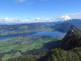
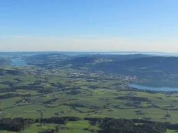
panoramic view: Great panorama
Paths covering:
Asphalt, Path / trail, Other
powered by TOURDATA
Hike one of our most spectacular panoramic mountains from St. Lorenz!
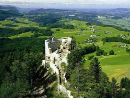
From the Höribachhof we take the hiking trail uphill and walk through the district of St. Lorenz. Initially on meadow paths, later in the forest to the forester's house or the Wartenfels ruins. Over partially exposed terrain, which is well insured with ropes, to the Schober. You can descend via the Frauenkopf and the Schober circular path which ends again at the forester's house.
If you end the hiking trail at the Wartenfels ruins (and do not continue to hike to the summit), the indicated walking time is reduced by approx. 1 hour.
Tip: On the way to the Schobergipfel in June you have the chance to see a "blooming lady's slipper" (Frauenschuh), a rare type of orchid. Here, besides other rare orchid species, the lady's slipper occurs in larger stocks.
Starting point: Public beach Schwarzindien
Destination: Public beach Schwarzindien
further information:
- Experience of nature
- Board possible
Accessibility / arrival
The starting point of our tour is the Höribach cultural property or the public bathing facility in "Schwarzindien". The public bathing area is about 2 kilometers from the center of Mondsee on the main road towards St. Gilgen.
- Parking space: 100
In summertime
- Suitable for groups
- Suitable for friends
- Suitable for couples
- Summer
- Autumn
Please get in touch for more information.
Dr. Franz Müller Straße 3
5310 St. Lorenz am Mondsee
Phone +43 6232 2270
Fax machine +43 6232 2270 - 22
E-Mail info@mondsee.at
Web www.mondsee.at
http://www.mondsee.at
Interactive elevation profile
Create PDF
Tour-Details
Starting place: 5310 St. Lorenz am Mondsee
Destination: 5310 St. Lorenz am Mondsee
duration: 6h 8m
length: 14,4 km
Altitude difference (uphill): 869m
Altitude difference (downhill): 854m
Lowest point: 484m
Highest point: 1.243m
difficulty: difficult
condition: difficult
panoramic view: Great panorama
Paths covering:
Asphalt, Path / trail, Other
powered by TOURDATA