

Schoberstein (1.037m)


- pets allowed
Interactive elevation profile
Create PDF
Tour-Details
Starting place: 4853 Steinbach am Attersee
Destination: 4853 Steinbach am Attersee
duration: 2h 30m
length: 6,2 km
Altitude difference (uphill): 523m
Altitude difference (downhill): 523m
Lowest point: 481m
Highest point: 986m
difficulty: difficult
condition: difficult
panoramic view: Great panorama
Paths covering:
Path / trail, Gravel, unfixed, Hiking trail
powered by TOURDATA
Trail AV 820
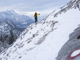
This short mountain tour leads to a popular summit in the Höllengebirge.
Hiking trail: n°820
Level of dificulty: easy mountain tour, sure-footedness and no fear of heights required. Bring your own provisions!
This short mountain tour up to the Schoberstein is one of the most beautiful excursions from the Attersee. The ascent starts at Weißenbach.
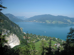
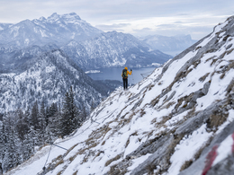
The hike takes around 1.5 hours and follows steep hairpin bends up to the rocky summit of the Schoberstein (1,037 m), which offers a magnificent view of the Attersee and the Mondsee. Up to the last resting place the tour is suitable for the whole family, but the last bit to the summit is not recommended for those with a low level of fitness and small children.
Those who do not want to take the same path back down to Weißenbach can continue on to the Dachsteinblick and via the Brennerriese back to the Forestry Office. The summit of the Brennerin makes for a rewarding detour from the Dachsteinblick.
Get inspired now and try the 360° perspective tour!
Refreshments:
Gasthaus „Zur Nixe“ - Tel. +43 7663 610
Hotel Post - Tel. +43 7663 8141
Café Fürthauer - Tel. +43 7663 229
This short mountain tour leads to a popular summit in the Höllengebirge.
Hiking trail: n°820
Level of dificulty: easy mountain tour, sure-footedness and no fear of heights required. Bring your own provisions!
This short mountain tour up to the Schoberstein is one of the most beautiful excursions from the Attersee. The ascent starts at Weißenbach.
The hike takes around 1.5 hours and follows steep hairpin bends up to the rocky summit of the Schoberstein (1,037 m), which offers a magnificent view of the Attersee and the Mondsee. Up to the last resting place the tour is suitable for the whole family, but the last bit to the summit is not recommended for those with a low level of fitness and small children.
Those who do not want to take the same path back down to Weißenbach can continue on to the Dachsteinblick and via the Brennerriese back to the Forestry Office. The summit of the Brennerin makes for a rewarding detour from the Dachsteinblick.
Get inspired now and try the 360° perspective tour!
Refreshments:
Gasthaus „Zur Nixe“ - Tel. +43 7663 610
Hotel Post - Tel. +43 7663 8141
Café Fürthauer - Tel. +43 7663 229
Parking
- Parking space: 30
There is a large parking lot on the avenue in Weißenbach next to the B152. There ist a fee from June to August: € 4.00 a day.
- Suitable for kids (6 - 14 Year)
- Pets allowed
- Suitable for single travelers
- Suitable for friends
- Suitable for couples
- Spring
- Summer
- Autumn
Please get in touch for more information.
Steinbach 5
4853 Steinbach am Attersee
Phone +43 7666 7719 - 60
E-Mail info.steinbach@attersee.at
Web attersee-attergau.salzkammergut.at
Web www.bergsteigerdoerfer.at/12-0-Berg…
https://attersee-attergau.salzkammergut.at
http://www.bergsteigerdoerfer.at/12-0-Bergsteigerdorf-Steinbach-am-Attersee.html
http://www.bergsteigerdoerfer.at/12-0-Bergsteigerdorf-Steinbach-am-Attersee.html
You can also visit us on
Visit us on Facebook Visit our videochannel on YouTube WikipediaInteractive elevation profile
Create PDF
Tour-Details
Starting place: 4853 Steinbach am Attersee
Destination: 4853 Steinbach am Attersee
duration: 2h 30m
length: 6,2 km
Altitude difference (uphill): 523m
Altitude difference (downhill): 523m
Lowest point: 481m
Highest point: 986m
difficulty: difficult
condition: difficult
panoramic view: Great panorama
Paths covering:
Path / trail, Gravel, unfixed, Hiking trail
powered by TOURDATA