

Brennerin


- pets allowed
- Suitable for families
Interactive elevation profile
Create PDF
Tour-Details
Starting place: 4853 Steinbach am Attersee
Destination: 4853 Steinbach am Attersee
duration: 6h 0m
length: 10,0 km
Altitude difference (uphill): 1.083m
Altitude difference (downhill): 1.052m
Lowest point: 472m
Highest point: 1.584m
difficulty: difficult
condition: difficult
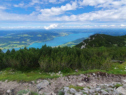
panoramic view: Great panorama
Paths covering:
Gravel, unfixed, Hiking trail, Other
powered by TOURDATA
Hiking trail # AV 821
This challenging mountain tour leads over steep terrain and serpentines, but offers a great panoramic view.
Starting Point: Forstamt
Starting from "Forstamt" the path will lead us through the forest and then up a short iron ladder to the "Steinbach view." Steep rise above the "Brennerriesensteig" on the "Höllengebirge" -
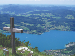
recommended only for experienced hikers. The summit cross is located at an altitude of 1602 m with a fantastic view.
After a short break, we follow the steep switchbacks up the "Dachstein view". Here you have the opportunity to do a tightrope walk along the beautiful Mahdlschneid down to Schoberstein and further to Weissbach.
Alternatively, you can take the slightly de- and ascending way to the rescue mountain hut Hochleckenhaus .
This challenging mountain tour leads over steep terrain and serpentines, but offers a great panoramic view.
Starting Point: Forstamt
Starting from "Forstamt" the path will lead us through the forest and then up a short iron ladder to the "Steinbach view." Steep rise above the "Brennerriesensteig" on the "Höllengebirge" -
recommended only for experienced hikers. The summit cross is located at an altitude of 1602 m with a fantastic view.
After a short break, we follow the steep switchbacks up the "Dachstein view". Here you have the opportunity to do a tightrope walk along the beautiful Mahdlschneid down to Schoberstein and further to Weissbach.
Alternatively, you can take the slightly de- and ascending way to the rescue mountain hut Hochleckenhaus .
Parking
- Parking space: 5
- Suitable for groups
- Suitable for schools
- Suitable for kids (6 - 14 Year)
- Pets allowed
- Suitable for friends
- Suitable for couples
- Spring
- Summer
- Autumn
Please get in touch for more information.
4853 Steinbach am Attersee
Phone +43 7666 7719 - 60
E-Mail info.steinbach@attersee.at
Web attersee-attergau.salzkammergut.at
Web www.bergsteigerdoerfer.at/18-0-Berg…
https://attersee-attergau.salzkammergut.at
http://www.bergsteigerdoerfer.at/18-0-Bergtouren-rund-um-Steinbach-am-Attersee.html
http://www.bergsteigerdoerfer.at/18-0-Bergtouren-rund-um-Steinbach-am-Attersee.html
Interactive elevation profile
Create PDF
Tour-Details
Starting place: 4853 Steinbach am Attersee
Destination: 4853 Steinbach am Attersee
duration: 6h 0m
length: 10,0 km
Altitude difference (uphill): 1.083m
Altitude difference (downhill): 1.052m
Lowest point: 472m
Highest point: 1.584m
difficulty: difficult
condition: difficult
panoramic view: Great panorama
Paths covering:
Gravel, unfixed, Hiking trail, Other
powered by TOURDATA