

Jagastüberl steep & Buchberg Peak


- All weather
- Suitable for families
Interactive elevation profile
Create PDF
Tour-Details
Starting place: 4864 Attersee am Attersee
Destination: 4864 Attersee am Attersee
duration: 1h 16m
length: 1,9 km
Altitude difference (uphill): 311m
Altitude difference (downhill): 15m
Lowest point: 488m
Highest point: 783m
difficulty: medium
condition: medium
panoramic view: Great panorama
Paths covering:
Asphalt, Path / trail, Gravel, Street, Hiking trail
powered by TOURDATA
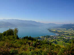
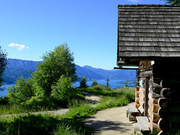
A great summit experience on the Buchberg with distant views over the beautiful landscape of Lake Attersee from the "Jagastüberl".
Please note: cycling on the Buchberg is prohibited!
The starting point of this tour is at the Atterseehalle, where you orient yourself along the parallel road in the direction of the forest. At the edge of the forest begins the path, which first leads a piece along the Schlossbergrunde and the Walderlebnisweg. At the next fork, keep left and follow the path until you reach the forest road. Here you go to the right on the forest road for a while until a sign shows you the way to go. Here you can decide whether to choose the steep ascent to the left or to stay on the forest road that also leads to the summit. If you choose the steep path, after a while you will meet another forest road, which you follow to the right again. After a bend to the left, continue left along a hiking trail through the forest, which is very steep. This leads directly to the summit of the Buchberg. After a rest at the summit at the Jägerstüberl hut with a great view, you can either take the same path back or go back to the starting point via the forest road to Attersee.
Starting point: Atterseehalle - Waldweg
Destination: Atterseehalle - Waldweg
further information:
- Experience of nature
- Board possible
Accessibility / arrival
By car:
From Salzburg take the motorway A1 – exit St. Georgen im Attergau – left sight Attersee
From Vienna/Linz take motorway A1 – exit St. Georgen im Attergau – left sight Attersee
From Westside – Bad Ischl – Weißenbachtal – Unterach – Nußdorf – Attersee
By train:
From Salzburg or Vienna/Linz to Vöcklamarkt, change the ÖBB-train to Attergaubahn to Attersee
By plane:
From Salzburg take the motorway A1 – exit St. Georgen im Attergau – left sight Attersee
From Vienna/Linz take the motorway A1 – exit St. Georgen im Attergau – left sight Attersee
- Parking space: 10
- All weather
- Suitable for groups
- Suitable for schools
- Suitable for kids (5 - 14 Year)
- Suitable for teenagers
- Suitable for seniors
- Suitable for single travelers
- Suitable for friends
- Suitable for couples
- Suitable for children
- Spring
- Summer
- Autumn
Please get in touch for more information.
")
Attergaustraße 55
4880 St. Georgen im Attergau
Phone +43 7666 7719 - 80
E-Mail info@attersee.at
Web attersee-attergau.salzkammergut.at
https://attersee-attergau.salzkammergut.at
You can also visit us on
Visit us on Facebook Visit us on Instagram Visit us on Pinterest Visit our videochannel on YouTube Wikipedia")
")
Interactive elevation profile
Create PDF
Tour-Details
Starting place: 4864 Attersee am Attersee
Destination: 4864 Attersee am Attersee
duration: 1h 16m
length: 1,9 km
Altitude difference (uphill): 311m
Altitude difference (downhill): 15m
Lowest point: 488m
Highest point: 783m
difficulty: medium
condition: medium
panoramic view: Great panorama
Paths covering:
Asphalt, Path / trail, Gravel, Street, Hiking trail
powered by TOURDATA