

Panorama Hiking Trail village Attersee


- pets allowed
- All weather
- Suitable for families
- Suitable for kids (all ages)
- culturally interesting
- Flatly
- Possible accommodation
Interactive elevation profile
Create PDF
Tour-Details
Starting place: 4864 Attersee am Attersee
Destination: 4864 Attersee am Attersee
duration: 1h 15m
length: 4,7 km
Altitude difference (uphill): 55m
Altitude difference (downhill): 63m
Lowest point: 484m
Highest point: 536m
difficulty: easy
condition: medium
panoramic view: Great panorama
Paths covering:
Gravel, Street, Hiking trail, Other
powered by TOURDATA
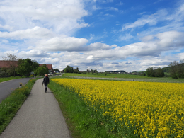
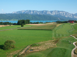
Enjoy the beautiful panoramic view of Lake Attersee and the mountain range "Hoellengebirge" during this 4,7 km hike.
You start this varied hike at the church in Abtsdorf in Attersee am Attersee. At the children's playground you keep to the right, cross a road a little later and continue straight on until you reach a small shrine, where you turn left.
A forest road now leads across the fields and through a short stretch of forest until you reach Winterleithen and Breitenröth.
At the fork in the road you can take a look at the Schuster Chapel before continuing the hike to our left (downhill). At the cobbler's cross you turn left again. About 300 meters later you leave the asphalt road and walk on a goods road to the right through the meadows and fields to Aufham.
There you turn left at the eastern edge, follow the road for a short distance through the residential area before continuing left again. After a short time you meet a crossing road, which brings you back to Abtsdorf on the left.
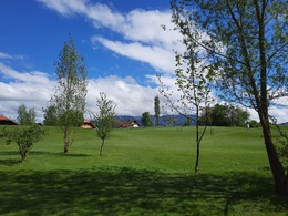
Back at the starting point of the parish church in Abtsdorf, it is recommended to take a look inside the church. The late Gothic parish church "Zum Heiligen Laurentius" impresses with a net-ribbed vault. The pulpit as well as the altars are by the Mondsee baroque sculptor Meinrad Guggenbichler.
REFRESHMENT STOPS:
Hemetsberger Inn
Kreuzer Inn
Hotel Alpenblick
You start this varied hike at the church in Abtsdorf in Attersee am Attersee. At the children's playground you keep to the right, cross a road a little later and continue straight on until you reach a small shrine, where you turn left.
A forest road now leads across the fields and through a short stretch of forest until you reach Winterleithen and Breitenröth.
At the fork in the road you can take a look at the Schuster Chapel before continuing the hike to our left (downhill). At the cobbler's cross you turn left again. About 300 meters later you leave the asphalt road and walk on a goods road to the right through the meadows and fields to Aufham.
There you turn left at the eastern edge, follow the road for a short distance through the residential area before continuing left again. After a short time you meet a crossing road, which brings you back to Abtsdorf on the left.
Back at the starting point of the parish church in Abtsdorf, it is recommended to take a look inside the church. The late Gothic parish church "Zum Heiligen Laurentius" impresses with a net-ribbed vault. The pulpit as well as the altars are by the Mondsee baroque sculptor Meinrad Guggenbichler.
REFRESHMENT STOPS:
Hemetsberger Inn
Kreuzer Inn
Hotel Alpenblick
Starting point: Parish Church "Zum Heiligen Laurentius" in Abtsdorf in Attersee am Attersee
Destination: Parish Church "Zum Heiligen Laurentius" in Abtsdorf in Attersee am Attersee
further information:
- Flatly
- Possible accommodation
- Board possible
Accessibility / arrival
Car:
From Salzburg via A1 - exit St. Georgen im Attergau - left direction Attersee.
From Vienna/Linz via A1 - exit St. Georgen im Attergau - left direction Attersee
From the west - Bad Ischl - Weißenbachtal - Unterach - Nußdorf - Attersee
By train:
Coming from Salzburg or Linz/Vienna to Vöcklamarkt, continue with the Attergaubahn to Attersee.
Plane:
From Salzburg via A1 - exit St. Georgen im Attergau - left direction Attersee.
From Vienna/Linz via A1 - exit St. Georgen im Attergau - left direction Attersee
- Parking space: 10
- All weather
- Suitable for groups
- Suitable for schools
- Suitable for kids (all ages)
- Pets allowed
- Suitable for teenagers
- Suitable for seniors
- Suitable for single travelers
- Suitable for friends
- Suitable for couples
- Spring
- Summer
- Autumn
- Early winter
Please get in touch for more information.
")
Attergaustraße 55
4880 St. Georgen im Attergau
Phone +43 7666 7719 - 80
E-Mail info@attersee.at
Web attersee-attergau.salzkammergut.at/
Web www.attersee.ooe.gv.at
https://attersee-attergau.salzkammergut.at/
http://www.attersee.ooe.gv.at
http://www.attersee.ooe.gv.at
You can also visit us on
Visit us on Facebook Visit us on Instagram Visit us on Pinterest Visit our videochannel on YouTube Wikipedia")
")
")

Interactive elevation profile
Create PDF
Tour-Details
Starting place: 4864 Attersee am Attersee
Destination: 4864 Attersee am Attersee
duration: 1h 15m
length: 4,7 km
Altitude difference (uphill): 55m
Altitude difference (downhill): 63m
Lowest point: 484m
Highest point: 536m
difficulty: easy
condition: medium
panoramic view: Great panorama
Paths covering:
Gravel, Street, Hiking trail, Other
powered by TOURDATA