

Tar Oil Path (Pechölweg) in Elz


- All weather
- Suitable for families
- Flatly
Interactive elevation profile
Create PDF
Tour-Details
Starting place: 4292 Kefermarkt
Destination: 4292 Kefermarkt
duration: 0h 52m
length: 2,8 km
Altitude difference (uphill): 88m
Altitude difference (downhill): 85m
Lowest point: 616m
Highest point: 697m
difficulty: easy
condition: easy
panoramic view: Some Views
Paths covering:
Asphalt, Gravel, Hiking trail
powered by TOURDATA
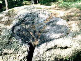
This short circular route takes us to Elz’s pitchstones, where tar oil was extracted from resin-rich pine wood. On particularly clear days, visitors are treated to beautiful Alpine views. Hiking map and information on this educational path are available at the market office.
Starting point: Directly from the Brungraber village inn, the Sepp ‘n Wirt
further information:
- Flatly
Details - hiking
- educational path
Always open!
Please note that snow is not cleared during the winter months.
Accessibility / arrival
By car:
Take the A7 (Mühlkreisautobahn) from Linz towards Freistadt/Prague. When the motorway ends in Unterweitersdorf, turn left onto the B310 towards Freistadt/Prague. Follow the road for about 10 km, then turn right towards Kefermarkt at the junction (Linz-Kefermarkt = 33 km)
By train:
Train: Linz Central Station to Kefermarkt = 43 km (Linz - Summerau - Prague railway line)
- All weather
- Suitable for groups
- Suitable for schools
- Spring
- Summer
- Autumn
Please get in touch for more information.

Markt 26
4292 Kefermarkt
Phone +43 7947 7255 - 13
E-Mail marktgemeinde@lasberg.ooe.gv.at
Web www.lasberg.at
Web www.muehlviertel-urlaub.at/wandern
http://www.lasberg.at
http://www.muehlviertel-urlaub.at/wandern
http://www.muehlviertel-urlaub.at/wandern
Interactive elevation profile
Create PDF
Tour-Details
Starting place: 4292 Kefermarkt
Destination: 4292 Kefermarkt
duration: 0h 52m
length: 2,8 km
Altitude difference (uphill): 88m
Altitude difference (downhill): 85m
Lowest point: 616m
Highest point: 697m
difficulty: easy
condition: easy
panoramic view: Some Views
Paths covering:
Asphalt, Gravel, Hiking trail
powered by TOURDATA