

Rundweg Brand


- culinary interesting
- Flatly
Interactive elevation profile
Create PDF
Tour-Details
Path number: K71
Starting place: 4554 Oberschlierbach
Destination: 4554 Oberschlierbach
duration: 2h 10m
length: 6,5 km
Altitude difference (uphill): 277m
Altitude difference (downhill): 283m
Lowest point: 582m
Highest point: 753m
difficulty: easy
condition: easy
panoramic view: Great panorama
Paths covering:
Asphalt, Gravel, Hiking trail
powered by TOURDATA
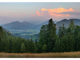
Enjoy the marvellous view of the Krems and Steyr valleys.
The Brand and Gruabholz circular hiking trails have the same route in the first and last sections. Starting from the town square, you walk along the road for a short while before turning off onto a forest road. Continue downhill to a bee hut and an old Holzknecht hut. The two circular hiking trails divide here. Keep left and hike uphill to the "Kaiseredt" holiday and organic farm. A children's playground and benches invite you to linger. Bread is baked here on Fridays (available to buy). On the way to the starting point, the many colourful flowers on the embankments and the magnificent view of the Kremstal, the Grillenparz, the Kremsmauer, the Tote Gebirge, the Sensengebirge and the Traunstein are fascinating.
The Brand and Gruabholz circular hiking trails have the same route in the first and last sections. Starting from the town square, you walk along the road for a short while before turning off onto a forest road. Continue downhill to a bee hut and an old Holzknecht hut. The two circular hiking trails divide here. Keep left and hike uphill to the "Kaiseredt" holiday and organic farm. A children's playground and benches invite you to linger. Bread is baked here on Fridays (available to buy). On the way to the starting point, the many colourful flowers on the embankments and the magnificent view of the Kremstal, the Grillenparz, the Kremsmauer, the Tote Gebirge, the Sensengebirge and the Traunstein are fascinating.
Parking
- Parking space: 30
Most economical season
- Spring
- Summer
- Autumn
- Early winter
Please get in touch for more information.
4400 Steyr
Phone +43 7582 63474
E-Mail kirchdorf@steyr-nationalpaprk.at
Web www.steyr-nationalpark.at
https://www.steyr-nationalpark.at
Interactive elevation profile
Create PDF
Tour-Details
Path number: K71
Starting place: 4554 Oberschlierbach
Destination: 4554 Oberschlierbach
duration: 2h 10m
length: 6,5 km
Altitude difference (uphill): 277m
Altitude difference (downhill): 283m
Lowest point: 582m
Highest point: 753m
difficulty: easy
condition: easy
panoramic view: Great panorama
Paths covering:
Asphalt, Gravel, Hiking trail
powered by TOURDATA