

MTB-Tour Reichraming-Brunnbach


- Flatly
Interactive elevation profile
Create PDF
Tour-Details
Starting place: 4462 Reichraming
Destination: 4462 Reichraming
duration: 4h 25m
length: 36,6 km
Altitude difference (uphill): 743m
Altitude difference (downhill): 743m
Lowest point: 349m
Highest point: 772m
difficulty: medium
condition: medium
panoramic view: Dreamtour
Paths covering:
Asphalt, Gravel, Hiking trail, Other
powered by TOURDATA
Short description:
The tour leads from Reichraming along the Reichramingbach to Anzenbach and over the Brennhöhe to Brunnbach. Through the Plaißagraben it goes back to the starting point.
The tour leads from Reichraming along the Reichramingbach to Anzenbach and over the Brennhöhe to Brunnbach. Through the Plaißagraben it goes back to the starting point.
Recommended season:
- April
- May
- June
- July
- August
- September
- October
Properties:
- Loop
Impressive MTB tour.
Directions:
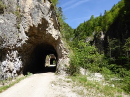
In Brunnbach past the Brunnbachstadl straight across the intersection, past the Bildungshaus Brunnbachschule and after 190 m on the gravel road through the Weyrer Brunnbachgraben up.Right uphill towards "Kogler Alm", after approx. 1 km it becomes flatter; it goes around a rocky ledge and after 800 m downhill again to the alpine pasture.After about a kilometer, turn right again out through the Brunnbach valley, across the parking lot and on the asphalt road past the former Stonitsch inn.At the junction in Brunnbach, turn left into the Plaißagraben. After 330 m at the turnoff to Brennhöhe continue straight ahead through the valley. At the turnoff near the Maieralm, the tour continues straight ahead, next to the Reichramingbach stream and through a tunnel to the Anzenbach barrier - here you keep left and return to Reichraming on the asphalt road.Variants: Start in Großraming, approach via Lumplgraben - Gschwendthöhe to Brunnbach.
Safety guidelines:
Inquire in advance about any road or trail closures along the route.
Equipment:
Sun and rain protection, possibly take bike repair kid.
Additional information:
Sun and rain protection, possibly take bike repair kid.
Starting point: Reichraming
Destination: Reichraming
further information:
- Flatly
details mountainbike
- Riding technique: very easy
- Suitable for teenagers
- Suitable for seniors
- Suitable for single travelers
- Suitable for friends
- Suitable for couples
- Spring
- Summer
- Autumn
Please get in touch for more information.
Stadtplatz 27
4400 Steyr
Phone +43 7252 53229 - 0
E-Mail reichraming@steyr-nationalpark.at
Web www.steyr-nationalpark.at/
https://www.steyr-nationalpark.at/
Interactive elevation profile
Create PDF
Tour-Details
Starting place: 4462 Reichraming
Destination: 4462 Reichraming
duration: 4h 25m
length: 36,6 km
Altitude difference (uphill): 743m
Altitude difference (downhill): 743m
Lowest point: 349m
Highest point: 772m
difficulty: medium
condition: medium
panoramic view: Dreamtour
Paths covering:
Asphalt, Gravel, Hiking trail, Other
powered by TOURDATA