

Magdalena Mountain Path


- All weather
- Suitable for families
- Flatly
Interactive elevation profile
Create PDF
Tour-Details
Starting place: 4701 Bad Schallerbach
Destination: 4701 Bad Schallerbach
duration: 1h 18m
length: 4,5 km
Altitude difference (uphill): 105m
Altitude difference (downhill): 98m
Lowest point: 304m
Highest point: 400m
difficulty: medium
condition: medium
panoramic view: Some Views
Paths covering:
Asphalt
powered by TOURDATA
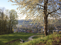
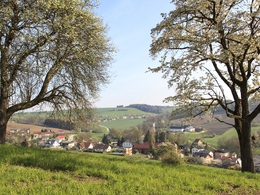
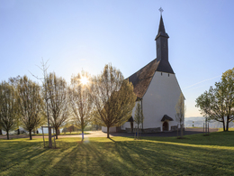
Starting from Europaplatz / Atrium through the center to the gothic Magdalenaberg church (built in the 14th century) and back. Average increase and decline.
Free hiking map available at the Tourist-Infos Bad Schallerbach and Gallspach
Free hiking map available at the Tourist-Infos Bad Schallerbach and Gallspach
Starting point: Europaplatz
Destination: Europaplatz
further information:
- Flatly


")


Accessibility / arrival
by car:
Coming on the A8 from Passau, take the Pichl exit.
On the A8 coming from Linz, exit Pichl
by train:
Vienna-Linz-Wels-Bad Schallerbach-Passau-Nuremberg-Frankfurt a. Main
- Free entry
- All weather
- Suitable for groups
- Suitable for schools
- Suitable for teenagers
- Suitable for seniors
- Suitable for single travelers
- Suitable for friends
- Suitable for couples
- Spring
- Summer
- Autumn
Please get in touch for more information.
Promenade 2
4701 Bad Schallerbach
Phone +43 7249 42071
Fax machine +43 7249 42071 - 13
E-Mail info@vitalwelt.at
Web www.vitalwelt.at
http://www.vitalwelt.at
Interactive elevation profile
Create PDF
Tour-Details
Starting place: 4701 Bad Schallerbach
Destination: 4701 Bad Schallerbach
duration: 1h 18m
length: 4,5 km
Altitude difference (uphill): 105m
Altitude difference (downhill): 98m
Lowest point: 304m
Highest point: 400m
difficulty: medium
condition: medium
panoramic view: Some Views
Paths covering:
Asphalt
powered by TOURDATA