

3-Seen-Tour - Über die Langbathseen zum Traunsee


Interactive elevation profile
Create PDF
Tour-Details
Starting place: 4802 Ebensee
Destination: 4802 Ebensee
duration: 3h 0m
length: 34,0 km
Altitude difference (uphill): 882m
Altitude difference (downhill): 883m
Lowest point: 421m
Highest point: 860m
difficulty: medium
condition: medium
panoramic view: Some Views
Paths covering:
Gravel
powered by TOURDATA
information: Information freigegebene Zeiten
3-lake tour - via the Langbath lakes to the Traunsee.
From Ebensee town hall, the route first leads along the Langbathsee district road past the valley station of the Feuerkogel cable car. To the side, the Langbathbach babbles over small artificial cascades and provides welcome cooling.
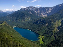
After about 4 kilometres, a forest road branches off to the left just before a hunting lodge. After a short ascent, you reach the Vorderer Langbathsee lake on a wide, wooded valley floor against the backdrop of the northern slopes of the Höllengebirge mountains. Please drive very slowly in the area of the two lakes, as many adults and children circle the lakes.
Continue along the right bank of this popular excursion destination to Hinterer Langbathsee, which is a "stick" higher and is reached after a long ascent. This lake with its unique view of the mighty summit cross of the Brunnkogel invites you to take a break and enjoy a refreshing footbath, as the only "mountain climb", the approximately 1 km long ascent to the Lueg (830 m), on which 100 metres in altitude are conquered, lies ahead. The summit of the tour has been reached, from now on it's all downhill.
After a short section of walking through a forest, you reach a forest road where you turn right downhill and, after a 3 km long, relaxing descent, join the Großalm district road. Via Neukirchen, you roll gently downhill to Traunkirchen on tarmac roads, with the basin of Lake Traun in front of you. Along the Salzkammergut federal road B145, you cycle from Traunkirchen to Ebensee on the cycle path.
Before the ascent to the Kleiner Sonnstein, directly at the tunnel portal, you have to cross the road to the left at the junction (be careful!!!), as the cycle path continues on the left-hand side of the B145. Since the construction of three road tunnels through the Sonnstein, a long section of the old lakeside road has been reserved for bikers and walkers, allowing them to enjoy the ride along the steep banks of Lake Traunsee.
From Ebensee town hall, the route first leads along the Langbathsee district road past the valley station of the Feuerkogel cable car. To the side, the Langbathbach babbles over small artificial cascades and provides welcome cooling.
After about 4 kilometres, a forest road branches off to the left just before a hunting lodge. After a short ascent, you reach the Vorderer Langbathsee lake on a wide, wooded valley floor against the backdrop of the northern slopes of the Höllengebirge mountains. Please drive very slowly in the area of the two lakes, as many adults and children circle the lakes.
Continue along the right bank of this popular excursion destination to Hinterer Langbathsee, which is a "stick" higher and is reached after a long ascent. This lake with its unique view of the mighty summit cross of the Brunnkogel invites you to take a break and enjoy a refreshing footbath, as the only "mountain climb", the approximately 1 km long ascent to the Lueg (830 m), on which 100 metres in altitude are conquered, lies ahead. The summit of the tour has been reached, from now on it's all downhill.
After a short section of walking through a forest, you reach a forest road where you turn right downhill and, after a 3 km long, relaxing descent, join the Großalm district road. Via Neukirchen, you roll gently downhill to Traunkirchen on tarmac roads, with the basin of Lake Traun in front of you. Along the Salzkammergut federal road B145, you cycle from Traunkirchen to Ebensee on the cycle path.
Before the ascent to the Kleiner Sonnstein, directly at the tunnel portal, you have to cross the road to the left at the junction (be careful!!!), as the cycle path continues on the left-hand side of the B145. Since the construction of three road tunnels through the Sonnstein, a long section of the old lakeside road has been reserved for bikers and walkers, allowing them to enjoy the ride along the steep banks of Lake Traunsee.
E-service station / recharging station
- Charging point for electric cars (fees apply)
- Charging point for e-bikes (free of charge)
Most economical season
- Summer
Please get in touch for more information.
Langbathtal, Neukirchen und Traunkirchen
4802 Ebensee
Phone +43 6133 8016
Fax machine +43 6133 8016870
E-Mail ebensee@traunsee-almtal.at
Web www.traunsee-almtal.at/ebensee
http://www.traunsee-almtal.at/ebensee
Interactive elevation profile
Create PDF
Tour-Details
Starting place: 4802 Ebensee
Destination: 4802 Ebensee
duration: 3h 0m
length: 34,0 km
Altitude difference (uphill): 882m
Altitude difference (downhill): 883m
Lowest point: 421m
Highest point: 860m
difficulty: medium
condition: medium
panoramic view: Some Views
Paths covering:
Gravel
powered by TOURDATA