

Traunsee Klettersteig


Interactive elevation profile
Create PDF
Tour-Details
Starting place: 4810 Gmunden
Destination: 4810 Gmunden
duration: 4h 1m
length: 2,2 km
Altitude difference (uphill): 1.115m
Altitude difference (downhill): 31m
Lowest point: 497m
Highest point: 1.614m
difficulty: difficult
condition: difficult
panoramic view: Some Views
Paths covering:
Climbing mount
powered by TOURDATA
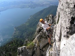
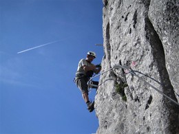
A very beautiful and well-built via ferrata which, in combination with the Hans Hernler via ferrata, makes for a challenging mountain adventure. The very airy via ferrata is a very difficult sport via ferrata - often with D grades, rarely easier and leads over a vertical rock pillar over an altitude difference of around 150 metres to the summit of the Traunstein. The climb ends directly in the "beer garden" of the Gmundner Hütte. If you don't feel up to this difficult climb, simply follow the neighbouring Hans Hernler-Steig (B) to the Gmundner Hütte.
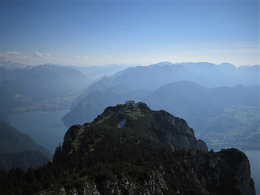
Due to the long ascent (3 hours!) and the difficult climbing sections, fitness is the main requirement here! But once you have made it to the summit, you can expect a magnificent view of the Totes Gebirge, Dachstein and Lake Traunsee. Due to the south-west-facing location, take plenty of fluids with you in summer!
You can find detailed route information with a topo at: https://www.bergsteigen.com/touren/klettersteig/traunsee-klettersteig/
Starting point: Umkehrparkplatz Gmunden -Traunsteinstraße
further information:
- Board possible
Details - climbing mount
- difficulty acc. to Kurt Schall: very difficult (D)
- duration hop on: 6 h
- duration climbing mount: 3 h
- duration Descent: 2 h

- Suitable for friends
- Suitable for couples
- Summer
Please get in touch for more information.
Toscanapark 1
4810 Gmunden
Phone +43 7612 74451
E-Mail info@traunsee-almtal.at
Interactive elevation profile
Create PDF
Tour-Details
Starting place: 4810 Gmunden
Destination: 4810 Gmunden
duration: 4h 1m
length: 2,2 km
Altitude difference (uphill): 1.115m
Altitude difference (downhill): 31m
Lowest point: 497m
Highest point: 1.614m
difficulty: difficult
condition: difficult
panoramic view: Some Views
Paths covering:
Climbing mount
powered by TOURDATA